
Northern Pond Map
DIRECTIONS: Maps to the trails are available in a box on the bulletin board in the lobby of the Monroe Town Hall. To reach the area, drive east on Route 139 from the junction of Routes 141 and 139 and take the first left onto the Monroe Road. One mile farther on, turn left onto Dahlia Farm Road and in 1.5 miles watch for a small sign on the left: Northern Pond. In late spring, summer and fall, you can drive to a small parking area from which the trails depart. Beyond the small parking area, this access, which continues on to the canoe launch, is very rocky and uneven. It’s wise to proceed on foot or in four-wheel drive vehicles with high clearance. This access road is not plowed in winter. Then people park along the side of Dahlia Farm Road.
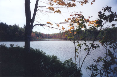
Not far into the woods off Dahlia Farm Road in Monroe, Maine, Northern Pond lies surrounded by marshland and upland forest of mixed hemlock, balsam, pine, spruce, birch, oak, and maple. Fed and drained by Thurlow Brook, the pond and surrounding area stretch unbroken for more than half a mile.

The pond has been a place for fishing, both summer and winter, for many years. Generations of children, first brought to the pond on family picnics, have spent their free hours there, fishing, finding frogs and beaver dams, watching birds, and creating their games.
